


Wales has been sculpted by wind and rain, but sometimes weather can prove destructive.
In late 2024, storms Bert and Darragh once again demonstrated the potential of weather to devastate communities. Weather and flood forecasters aim to predict severe weather before it hits, giving communities time to prepare.
In February and March 2025, the Senedd Climate Change, Environment, and Infrastructure Committee scrutinised Wales’s response to storms, including forecasting, warning, and alert systems.
This article explores current approaches to weather and flood forecasting, and uses the Committee’s inquiry to identify gaps and future developments.
Meet the forecasters
There are three key players in Wales’s weather and flood forecasting framework:
- the Met Office;
- the Flood Forecasting Centre ; and
- Natural Resources Wales.
All three use a combination of observations and computer models to try to anticipate disruptive conditions.
The Met Office
The Met Office provides the Public Weather Service and the National Severe Weather Warning Service. It is owned by the UK Government.
The Met Office issues yellow, amber, and red weather warnings when disruptive weather is forecast. Storms Bert and Darragh were preceded by yellow and amber warnings, respectively. Warnings can be issued for eight different weather types: based on a combination of an event’s likelihood and potential impact, using the impact matrix below.
Met Office weather warning matrix
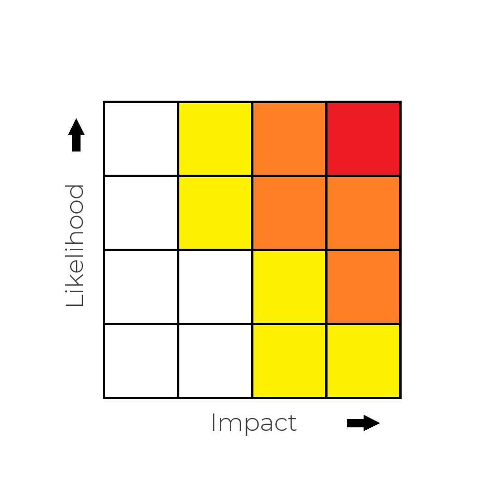
Source: Met Office
Flood Forecasting Centre
The FFC predicts the likelihood of river flooding in Wales and England using hydrological models and Met Office rain forecasts. The FFC is a joint programme of the Met Office and the Environment Agency (England’s equivalent of NRW), but its Welsh operations are conducted from a regional centre in Cardiff. An NRW spokesperson said there is “very close relationship” between itself and the FFC.
The FFC is not public-facing, but provides flooding data, forecasts and information to NRW and responder organisations. Its five-day Flood Guidance Statement is issued to local responders, and uses a similar risk likelihood and impact matrix to the Met Office.
Natural Resources Wales
NRW carries out real-time monitoring of river levels and issues three tiers of flood alerts and warnings when there is a risk of flooding, as shown below.
NRW flood alerts and warnings
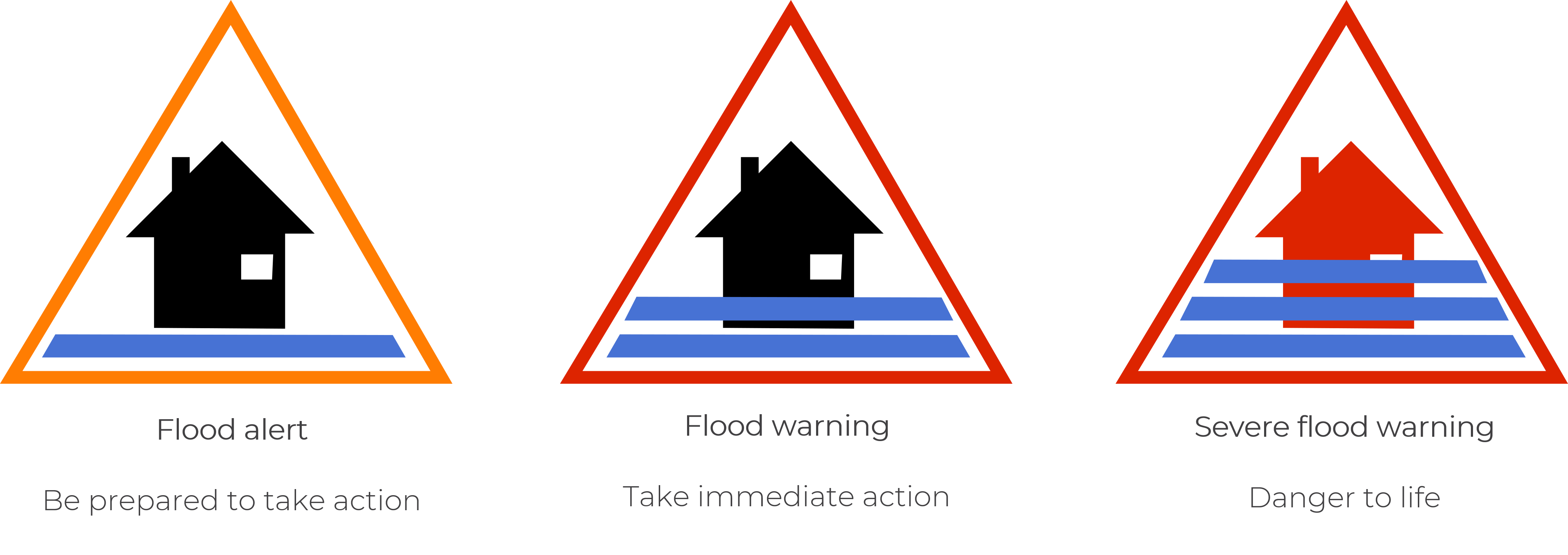
Source: Natural Resources Wales
NRW works with the FFC to model flood risk. An NRW spokesperson told the Committee NRW looks at flood risk and issues warnings at a community or local level, while the FFC looks at county-level risk.
Concerns about the current framework
Storm Bert caused extensive damage across Wales. In its aftermath, forecasters were criticised by Senedd politicians, who felt warnings were inadequate and too slow. The Committee’s inquiry aimed to identify why this had been the case.
The Met Office and FFC highlighted differences between the approach to storm prediction in Wales and England. The FFC Director told the Committee:
Whilst we started on common ground, the service is diverging as the needs diverge and investment levels diverge as well. So, it’s fair to say there’s a gap at the moment, and that gap potentially is growing in terms of the service that's provided.
He said forecasting in England has been driven by interest in extreme weather events, longer lead times, and a focus on surface water flooding. England has a computational approach to processing forecast data to predict flood risk, whilst NRW processes the same data “a bit more manually”, according to a spokesperson.
Almost 145,000 Welsh properties are at risk of ‘surface water and small watercourse’ flooding, compared to 106,000 from rivers, and 91,000 from the sea. However, there is currently no surface water flood forecasting in Wales or England. A Met Office spokesperson told the Committee that a trial surface water forecasting service would run in summer 2025.
NRW says flood warning signup levels “are not as high as we would want them to be”. It highlighted past efforts to increase uptake of its flood warning service.
36% of Welsh respondents to a 2024 British Red Cross (BRC) survey said they weren’t signed up for flood warnings “because they did not know how to or had not heard of them”. The BRC’s 2024 report found only 9% of the lowest income households across the UK were signed up for warnings, compared to 31% in the highest income areas.
Forecasters told the Committee they are mindful of not overissuing warnings. NRW said excessive flood warnings might mean “people start to lose faith in our systems”.
The Met Office issues yellow weather warnings for both low-likelihood, high-impact scenarios (including Storm Bert); and high-likelihood, low-impact scenarios. The Met Office will soon be reviewing its approach to medium- and high-impact yellow warnings, saying “people really act on ambers and reds”.
NRW said “about 84%” of areas with river flood warnings are supported by tailored models of flood risk, but it would like to increase this to 100% in future. In the remainder, warnings are issued using “observed data and historic records”. NRW plans to introduce forecasting at Cadoxton, Vale of Glamorgan, and on the rivers Wye and Dee, but “there are gaps in the Ebbw, Sirhowy catchments in south Wales, the Llanelli area, some areas in north Wales.” Some remote, isolated areas also lack flood warnings entirely.
Radar is important for real-time tracking of rainfall, which informs short-term flood risk. This is particularly important in narrow, steep-sided catchments such as the south Wales valleys. NRW told the Committee about radar coverage gaps in both south and north Wales, and says it’s considering additional radar investment alongside the Met Office and FFC.
Future forecasting: sunnier skies ahead?
As well as scrutinising the current work of forecasters, the Committee heard about possible future developments.
The Met Office says, in future, using ‘ensemble’ flood models could “better quantify uncertainty in meteorological, hydrological and impact forecasting, then ultimately warnings and alerts”. Ensemble models produce more reliable forecasts than traditional ‘deterministic’ models, and are already widely used in weather forecasting.
Forecasters are also developing a common warning framework, which seeks to maintain consistent in language and risk assessment between different forecasting organisations.
Extreme weather events have a profound psychological and financial impact on victims, as highlighted by the Committee’s public engagement report. With climate change, these events are expected to become more frequent and intense during this century, underscoring the importance of reliable forecasting in helping communities and individuals prepare for the challenges ahead.
Article by Dr Matt Sutton, Senedd Research, Welsh Parliament
